Alpine Loop
Delve into Colorado’s mining history
| Mileage | 12 miles (19 km) |
|---|---|
| DurationThe duration is an estimate of a one-way drive and does not include any stops or side-trips. | 49 minutes |
| SeasonsThe seasons listed are the best seasons for this scenic drive. If Winter is not mentioned, the road may be closed during the winter. | Summer, and Fall |
| Roadways | Forest Road 110 |
| Gravel Roads | Yes |
| ServicesThe cities or towns listed have either Food or Services such as gas, pharmacies, etc. | Silverton, CO▼, Telluride, CO▼, and Ouray, CO▼ |
| Rating | 3.6 average from 18 votes |
| My DrivesTrack your favorite scenic drives by selecting those which you want to take and those that you have taken. Using your free account, simply sign in and select My Drives. | |
| Share |
Our free Road Trip Planner will reverse the route and include the places of interests. Click the “Add to Road Trip” above to start planning your next road trip.
Send this link to your phone. Standard text messaging rates apply.
() -Get directions from your start address to the beginning of and including this scenic drive. Choose either an alternate ending or same as start.
Have more destinations? Use our free Road Trip Planner to completely plan your adventure. Click the “Add to Road Trip” above to start planning your next road trip.

This gravel road excursion through a land of mountain peaks and the rich history of mining and logging as you travel from Silverton to the ghost town of Animas Forks is a perfect side-trip off the San Juan Skyway. The area between Silverton and Animas Forks, and the first part of Cinnamon Pass are easily traveled by most vehicles (described here), but most of the loop is accessible only by high-clearance, four-wheel drive. If you yearn for off-road adventure, the surrounding communities have vehicles for rent.

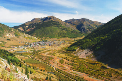
Following the Animas River, head east on CO-110 from Silverton where you will soon enter in the canyon walls. In Silverton, stop for a tour of Mayflower Gold Mill Tour (A1) which was operational for 61 years until 1991. Today, you can tour the old equipment and learn how gold, silver and other metals were extracted. (If you plan on seeing all of the historic attractions on this route, get the Heritage Pass which offers a discount for the Old Hundred Gold Mine Tour and adds the Mayflower Gold Mill and the Silverton Jail and Museum.) Spectacular scenery unfolds as you head towards Engineer Pass at more than 12,000 feet. Enjoy the winding road and breathtaking views of Precipice, Coxcomb, Wetterhorn and Matterhorn Peaks.
Continuing on CO-110, the canyon walls widen near Howardsville, a popular mining town for more than a hundred years. To the south of the town, is the Old Hundred Gold Mine (A2) where you can explore an underground mine and experience the thrill of panning for gold.
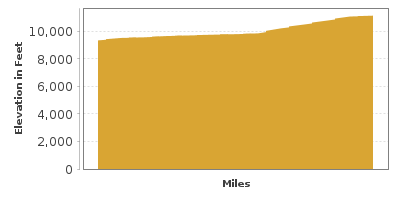
Continuing northward, the road climbs to Eureka, where the road narrows to one lane with plenty of turn-outs to enjoy the scenery. The road continues its climb until you arrive in Animas Forks, a fascinating ghost town with remnants of what was once a thriving mining town. Above the tree line, the picturesque wildflower fields and surrounding peaks make the gravel trek well worth it. Many different types of wildlife call this area home and if you look closely big horn sheep, moose, mountain lions, bobcats and bear may be spotted.
The official byway continues west on Country Road 3 towards Lake City, and loops back on Country Road 20 to Animas Forks for those interested and prepared for off-road adventure.
Our car-friendly road trip returns to Silverton by continuing onto Country Road 9, Country Road 19 and Country Road 10 which will lead back to CO-110. In Silverton, you can continue on the San Juan Skyway.
Other Nearby Places of Interests
Bridal Veil Falls (H1): Bridal Veil Falls drops 425-feet off of a cliff, making it Colorado’s longest free-falling waterfall. The falls can be viewed from a number of vantage points and the adventurous will want to climb the 4-mile one way trail to the top.
Box Canyon Falls Park (H2): Clear Creek cascades 285-feet down through a narrow, limestone gorge. For the best view of the roaring waterfall, follow the short walkway to suspension bridge. The park itself features a Visitor Center with interpretive exhibits on the geology, wildlife, rare plant life and history of the area. Many gazebos, open meadow and forest make for great picnicking and the park has been designated an important bird watching area by the National Audubon Society.
Molas Lake (W1): Nestled between the peaks just north of Molas Pass, Molas Lake offers fishing, camping, and picnicking.


