Cascade Lakes
Explore lakes formed by volcanic activity and glaciers
| Mileage | 87 miles (141 km) |
|---|---|
| DurationThe duration is an estimate of a one-way drive and does not include any stops or side-trips. | 3 hours |
| SeasonsThe seasons listed are the best seasons for this scenic drive. If Winter is not mentioned, the road may be closed during the winter. | Spring, Summer, and Fall |
| Roadways | Oregon Highways 372, 42, 46, and 61, and US Highway 97 |
| PassesSome of the adventures on this scenic drive require an admission fee that these passes cover. Please read the drive description for more information. | Pacific Northwest Forest Passes (Washington, Oregon) |
| ServicesThe cities or towns listed have either Food or Services such as gas, pharmacies, etc. | Bend, OR▼, La Pine, OR▼, Three Rivers, OR▼, Sunriver, OR▼, and Deschutes River Woods, OR▼ |
| Rating | 3.4 average from 69 votes |
| My DrivesTrack your favorite scenic drives by selecting those which you want to take and those that you have taken. Using your free account, simply sign in and select My Drives. | |
| Share |
Our free Road Trip Planner will reverse the route and include the places of interests. Click the “Add to Road Trip” above to start planning your next road trip.
Send this link to your phone. Standard text messaging rates apply.
() -Get directions from your start address to the beginning of and including this scenic drive. Choose either an alternate ending or same as start.
Have more destinations? Use our free Road Trip Planner to completely plan your adventure. Click the “Add to Road Trip” above to start planning your next road trip.

Get a Park Pass
Natural areas along this route require an entrance fee used to protect and maintain our most scenic treasures. Save time by purchasing your forest passes before you go.
Past volcanic activity and glaciers have resulted in more than 150 lakes and amazing rock formations. Our mountain scenic drive starts in Bend and makes a loop along the Cascade Lakes Highway. Reaching Bend depends on where you are coming from, but it is accessible by US-97 and US-20.

Once in Bend, follow US-97 to exit 138 and follow SW Colorado Ave to the roundabout, and follow the signs for the Cascade Lakes Highway. Our scenic drive officially begins as you leave the city behind.
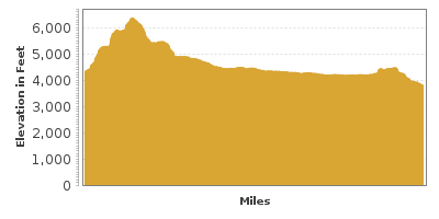
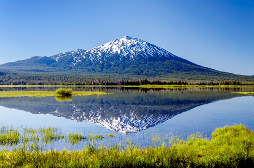
Heading west from Bend on Cascade Lakes Highway, the drive starts to climb and you will be surrounded by trees. About 16 miles from Bend, you will arrive at the foot of Mount Bachelor, 9,065 foot tall and part of the Cascade Range. In winter, Mount Bachelor is a premier ski resort. Its summit chairlift is open year-round and provides incredible panoramic views any season. On clear days you can see parts of California and Washington and the snow-capped volcanoes Broken Top and Three Sisters.
Continue west on OR-372. Fed by glaciers, Todd Lake (H9)is a wonderful place to stop, dip your toes, and revel in the wildflower meadows. Consider a side-trip on Sparks Lake Road to drive through a lava flow and reach Sparks Lake (W4), where you can enjoy swimming, canoeing, a picnic, or hiking.
As the road turns south, explore Devils Garden (H2) a fascinating lava field on your right. Nearby Devils Lake is particularly interesting for its optical illusion which makes objects floating on it look as if they were floating in thin air! This is caused by the white pumice at the bottom of the lake’s crystal clear water.
Three miles south on OR-46, you will approach picturesque Elk Lake (H3), with Mount Bachelor and South Sister peering out of the dense forests.
The Three Sisters Wilderness (H5) is to the west of Elk Lake and features 260 miles of trails to explore the untouched, natural beauty.
Twelve miles from Elk Lake, you can turn west (right) on Forest Road 4635 for two miles to reach Cultus Lake (W1). Cultus Lake has sandy beaches, perfect for swimming, windsurfing, and waterskiing.
Crane Prairie Reservoir (W2) is a man-made lake well known for fishing and is to the east of the drive. The reservoir is an excellent location to spot ducks, geese, fish hawks, and eagles.
Six miles from the Crane Prairie Reservoir, our drive turns left onto OR-42. Within a few miles, the Twin Lakes (W3) appear on your right. These two lakes are former volcano craters, now surrounded by astounding natural beauty.
Five miles from Twin Lakes, OR-42 and OR-43 split off. Our drive continues on OR-43, but you can’t go wrong in either direction. If you were to continue on OR-42, you will eventually follow the Deschutes River and that will bring you to the LaPine State Recreation Area (H6).
Turning right onto OR-43, our drive continues east for ten miles until we intersect with US-97. If you are in need of some services, head south on US-97 to LaPine. Our drive, though, continues north on US-97.
Approximately three and half miles on US-97, the road will intersect with OR-21. For an amazing side trip, consider taking OR-21 East to the Newberry National Volcanic Monument (H7), where you can visit a dormant, partially collapsed volcano. Inside are a waterfall, two lakes, and an obsidian lava flow.
One mile from OR-21, consider turning left onto State Recreation Road heading towards the LaPine State Recreation Area (H6), home to Oregon’s tallest ponderosa pine, at 191 feet. The area is also well known for the scenic Deschutes River, surrounding views and hikes.
Continuing north on US-97 for 11 miles, a right on FR-9700-100 will bring you to the Lava River Cave (H12), a hollow tube of lava that stretches for more than a mile.
One mile north from the Lava River Cave, you will reach Lava Lands Visitor Center (I1). From here, you can drive up the Lava Butte (V2), a 500-foot tall volcanic outcropping. From the top, you can see the cone’s crater and take in a breathtaking panoramic view.
Continuing north on US-97, our drive ends in 11 miles in Bend, where you may consider stopping at Drake Park (H8) which is right on the Deschutes River or heading up the Pilot Butte (V1) for another great view of the surrounding areas. From there, head north on US-97 and then west on US-20 towards Sisters for the McKenzie-Santiam Scenic Byway.
Other Nearby Places of Interests
Mount Bachelor (H1): Mount Bachelor is 9,068 feet high and is part of the Cascade Mountain Range. It has many hiking opportunities.
Lava Lake and Little Lava Lake (H10): The Little Lava Lake is about half of the size of Lava Lake and it is the source of the Deschutes River.
Lava Cast Forest (H13): The Lava Cast Forest has stone trees caused when lava swallowed a forest several thousand years ago.
Deschutes National Forest (I2)
High Desert Museum (M1): The High Desert Museum features both indoor and outdoor exhibits, featuring both natural and cultural history.


