Mount Hood
A drive through Mount Hood National Forest
| Mileage | 80 miles (130 km) |
|---|---|
| DurationThe duration is an estimate of a one-way drive and does not include any stops or side-trips. | 2 hours |
| SeasonsThe seasons listed are the best seasons for this scenic drive. If Winter is not mentioned, the road may be closed during the winter. | Spring, Summer, and Fall |
| Roadways | Oregon Highway 35, and US Highway 26 |
| PassesSome of the adventures on this scenic drive require an admission fee that these passes cover. Please read the drive description for more information. | Pacific Northwest Forest Passes (Washington, Oregon) |
| ServicesThe cities or towns listed have either Food or Services such as gas, pharmacies, etc. | Gresham, OR▼, Sandy, OR▼, Mount Hood Village, OR▼, and Hood River, OR▼ |
| Rating | 3.7 average from 67 votes |
| My DrivesTrack your favorite scenic drives by selecting those which you want to take and those that you have taken. Using your free account, simply sign in and select My Drives. | |
| Share |
Our free Road Trip Planner will reverse the route and include the places of interests. Click the “Add to Road Trip” above to start planning your next road trip.
Send this link to your phone. Standard text messaging rates apply.
() -Get directions from your start address to the beginning of and including this scenic drive. Choose either an alternate ending or same as start.
Have more destinations? Use our free Road Trip Planner to completely plan your adventure. Click the “Add to Road Trip” above to start planning your next road trip.

Get a Park Pass
Natural areas along this route require an entrance fee used to protect and maintain our most scenic treasures. Save time by purchasing your forest passes before you go.
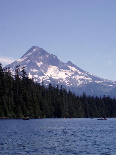
Mount Hood is highest point in Oregon at 11,240 feet and is the fourth tallest member of the Cascade Range. Although some believe that the volcano is dormant as it has not erupted in over a thousand years, it is considered potentially active and likely the next volcano to erupt in Oregon.

Our drive starts in Gresham and follows US-26 known locally as the Mount Hood Highway, and then heads north on OR-35 to Hood River. To start the drive, take exit 181 off of I-84 and head south on NE 181st Ave for just over a mile. Turn left onto Burnside Road and in about three and a half miles, our drive starts on US-26 in Gresham.
From Gresham, you will be driving through an area rich in farmlands. Stop at one of the “pick your own” farms or roadside stands to sample apples, berries, peaches, and more depending on the season. When you arrive in Sandy, stop and visit its historic sites or take a swim in the Sandy River at Dodge Park (H3).
After leaving Sandy, you will notice that the landscape changes as you climb into the Cascades. In fourteen miles, consider turning left onto Main Park Road for the Wildwood Recreation Area (H1), where you can enjoy hiking, picnics, and during the spring and fall, watch the salmon and trout in the Salmon River. One of the more popular trails is the Streamwatch trail, which will bring you to a unique viewpoint of the Salmon River.
In two miles, you will enter the Mount Hood National Forest. Covering more than one million acres, the Mount Hood National Forest is home to waterfalls, wildflowers, alpine lakes, birds, butterflies, and wildlife including mountain lions and black bears.
Two miles after entering the Mount Hood National Forest, Mount Hood Highway will intersect with Still Creek Road, and for a short scenic side trip, consider turning right onto Still Creek Road. This beautiful mountain scenic route will bring you through the forest and near Trillium Lake (H2). After 12 miles on Still Creek Road, turn left onto Chimney Rock Road, and then left onto East Perry Vickers Road until you rejoin Mount Hood Highway.
No drive to this area is complete without a stop at Mount Hood’s Timberline Lodge (I1). If you did not take Still Creek Road, turn left onto Timberline Highway about 11 miles from entering the forest. If you went via Still Creek Road, when you reach Mount Hood Highway, turn left and then a sharp right onto Timberline Highway. In just over five miles, you will be at the lodge, where you can get area information, hike, enjoy a meal in the lodge, or take the chairlift to the upper reaches of Mount Hood.
Back on US-26, consider a side trip to the mirror-like Trillium Lake at the bottom of Mount Hood that is perfect for swimming, hiking, and fishing. To reach it, turn south onto E. Perry Vickers Road from US-26. In a mile, take a slight right on E. Chimney Rock Road, and in a half a mile, turn onto NF-2612, and in just under a mile, you’ll be there.
Back on US-26, continue heading west. In two miles, US-26 forks into OR-35 and US-26. Forest Road 43 (T2) a nice side trip which you can reach by continuing on OR-26 to Cedar Burn Road and following Forest Road 48 to Tygh Valley and Oregon Rock Creek. For this scenic drive though, follow OR-35 to Bennett Pass.
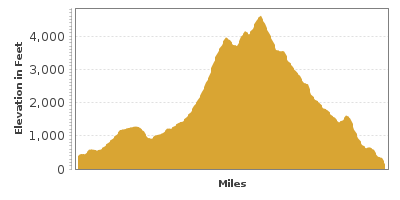
In six miles, you will be at 4,674 feet of elevation as you pass through Bennett Pass. As the drive descends, you will follow the rushing Hood River very closely for several miles, parting ways for several miles, and rejoining as the drive reaches the Columbia River.
On your way down, Panorama Point (V1) is a must stop for a spectacular panoramic view of the Columbia Gorge and surrounding beauty. To reach it, 31 miles from Bennett Pass, turn right onto Whiskey Creek Road. In a half mile, turn left onto Eastside Road and turn left for the viewpoint.
Our drive ends in the Town of Hood River, known for its historic buildings, boutiques, art galleries, restaurants and wineries. From here, follow our Columbia Gorge drive back either towards Portland or towards US-97.
Other Nearby Places of Interests
Mount Hood Railroad (A1): The Mount Hood Railroad offers excursions through the Mount Hood National Forests by train, reminiscing the impact railroads had in developing the area.
Bagby Natural Hot Springs (H4): The Bagby Natural Hot Springs is a 1.5 mile hike that leads to a natural hot spring near the Clackamas River.
Latourell Falls (H5): One of the many waterfalls along the Columbia Gorge. The Latourell Fall is in Guy W. Talbot State Park.
Portland Visitor Information Center (I2)
Still Creek Road (T1): Still Creek Road is an alternative road to US-26 that brings you through the forest. The road is two miles from the east entrance to the Mount Hood National Forest, where you will turn south. After 12 miles on Still Creek Road, turn left onto Chimney RockRoad, then left onto East Perry Vickers Road until you rejoin Mount Hood Highway (US-26).


