Ross Maxwell Scenic Drive
Big Bend National Park
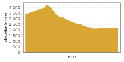
| Mileage | 30 miles (49 km) |
|---|---|
| DurationThe duration is an estimate of a one-way drive and does not include any stops or side-trips. | 54 minutes |
| SeasonsThe seasons listed are the best seasons for this scenic drive. If Winter is not mentioned, the road may be closed during the winter. | All Seasons |
| Roadways | Ross Maxwell Scenic Drive |
| PassesSome of the adventures on this scenic drive require an admission fee that these passes cover. Please read the drive description for more information. | America the Beautiful Annual National Parks Pass 2025-2026 |
| ServicesThe cities or towns listed have either Food or Services such as gas, pharmacies, etc. | Alpine, TX▼ |
| Rating | 3.9 average from 60 votes |
| My DrivesTrack your favorite scenic drives by selecting those which you want to take and those that you have taken. Using your free account, simply sign in and select My Drives. | |
| Share |
Our free Road Trip Planner will reverse the route and include the places of interests. Click the “Add to Road Trip” above to start planning your next road trip.
Send this link to your phone. Standard text messaging rates apply.
() -Get directions from your start address to the beginning of and including this scenic drive. Choose either an alternate ending or same as start.
Have more destinations? Use our free Road Trip Planner to completely plan your adventure. Click the “Add to Road Trip” above to start planning your next road trip.

Get a Park Pass
Natural areas along this route require an entrance fee used to protect and maintain our most scenic treasures. Save time by purchasing your forest passes before you go.
Big Bend National Park is about the size of Rhode Island and while all but two percent of the park is desert, the landscape is extremely diverse. From the Chisos Mountains in the center resembling a green island in the desert, to thermal springs adjacent the Rio Grande at the southern edge, the park is home to more types of birds, bats and cacti than any other national park in the U.S. including more than 60 species of cactus, 1,100 species of plants, 450 species of birds, 56 species of reptiles, 75 species of mammals and 3,600 species of insects.

The Ross Maxwell route is named for Big Bend National Park’s first superintendent and geologist who served from 1944-1952 and laid out the route to highlight the more spectacular geologic features on the west side of the park. The road heads between Burro Mesa and Chisos Mountains. The entire route takes at least a half of a day but you should leave time for exploring.
To reach Big Bend National Park, head south on US-385 from Marathon for 40 miles. After entering the park, you will be welcomed by mule deer, jackrabbits and hawks. Stop at Persimmon Gap (V6) where wildlife gathers and the Chisos Mountains rise in the distance. In spring, or after a rainfall, take the side-trip to Dagger Flat (T1) to see large Dagger Yuccas in full bloom with delicate white clusters of flowers.
Panther Junction is at the end of US-385. Stop at the Panther Junction Ranger Station (I1) for information, trail and weather conditions and exhibits on the geology, flora and fauna, and cultural history of the region. Don’t miss the nearby Panther Path, a self-guided nature trail. From here, consider a 20-mile side-trip to Rio Grande Village by heading east on Rio Grande Village Drive.
If you do the side trip, on the way to Rio Grande Village, you will pass Dugout Wells (H4), a former ranch community schoolhouse that is now a beautiful picnic spot surrounded by an oasis. A few hikes leave from here to explore the desert. Heading east for 18-miles, you arrive in Rio Grande Village, on the banks of the Rio Grande River and Mexico on the other side. Rio Grande Village features a number of short hikes, like the 3/4-mile round trip Rio Grande Village Nature Trail which offers opportunities for bird and wildlife watching, and at the trail’s end, an incredible panoramic view of the Sierra del Carmen, Boquillas, Hot Spring Canyon and the Chisos Mountains. It is also known to be the best sunset view of the entire park.
For this scenic drive, head west on Maverick Drive (TX-170). With so much to see, consider another side-trip in 3-miles, on Basin Drive (T2) where you can drive among massive cliffs and towering pinnacles, including Casa Grande formed by layers of lava and ash. There is also a visitor center, camping and the only restaurant and lodging in the entire park.
In 12-miles from Panther Junction, we finally arrive at the beginning of our scenic drive. Turn left onto Ross Maxwell Drive which passes between the Chisos Mountains to the east and Burro Mesa to the west. Along the windy road are a number of turnouts where you can see volcanic outcroppings and stunning vistas. Stop at Window Overlook (V3) which offers a view through a V-shaped notch in the Chisos Mountains to Casa Grande and desert beyond. From the Basin trailhead, hike the easy .3-mile round trip wheelchair accessible Window View Trail for another incredible vantage point.
A few miles ahead, Sotol Vista Overlook (V2) is another contender for best view, overlooking the western side of the park to Santa Elena Canyon and the Rio Grande. If you are in an RV or a vehicle with a trailer, you will not be able to continue beyond this stop due to the curves and grade.
Continuing on, take the 1.5 mile side road to Burro Mesa Pour-Off Trail (H1). A 1/2 mile trail leads to a desert pour-off, a narrow chute that provides run-off for rainwater. A variety of desert plants can be found here along with sweeping views.
Back on Ross Maxwell Road, stop at Mule Ears Overlook (V4) where you can see the aptly-named rock formation Mule Ear Peaks, created by underground volcanic activity about 25 million years ago. Further down the road, you arrive at Tuff Canyon (H2) formed from soft white volcanic tuff (compressed ash). And ahead, Cerro Castellan, 3,293 feet of multi-hued layers of lava and ash.
Continuing along, you soon past the former cavalry camp of Castolon (A1) where a frontier trading post is still open and antique equipment is on display. A visitor center is also located here.
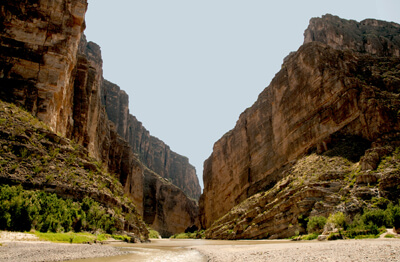
Eight miles from Castolon, is the extraordinary Santa Elena Overlook (V5). Peer into one of Big Bend National Park’s most spectacular scenes, where the Rio Grande carved a 1,500 foot chasm out of limestone and Texas makes up one wall, Mexico the other. Local outfitters organize floats down the river for day or overnight adventures.
The road ends shortly afterwards. From here, your choice is either to retrace the road back which offers a chance to re-examine the fabulous views or use the 13-mile, gravel Old Maverick Road (T3), which connects the Santa Elena Canyon to the town of Maverick at TX-118. Though generally well-maintained, check for road conditions especially after rains. Great desert views, badlands and primitive campsites will be found here. From Maverick, head west on TX-118 and continue on TX-170 to visit the Big Bend Ranch State Park via the El Camino del Rio.
Other Nearby Places of Interests
Rio Grande Village (H3): Rio Grande Village features a number of short hikes, like the 3/4-mile round trip Rio Grande Village Nature Trail which offers opportunities for bird and wildlife watching, and at the trail’s end, an incredible panoramic view of the Sierra del Carmen, Boquillas, Hot Spring Canyon and the Chisos Mountains. It is also known to be the best sunset view of the entire park.
Homer Wilson Ranch Overlook (V1)


