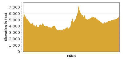
Glacier To Yellowstone
US-89 from Glacier National Park to Yellowstone National Park
| Mileage | 384 miles (618 km) |
|---|---|
| DurationThe duration is an estimate of a one-way drive and does not include any stops or side-trips. | 6 hours, 42 minutes |
| SeasonsThe seasons listed are the best seasons for this scenic drive. If Winter is not mentioned, the road may be closed during the winter. | All Seasons |
| Roadways | US Highway 89 |
| ServicesThe cities or towns listed have either Food or Services such as gas, pharmacies, etc. | Browning, MT▼, Choteau, MT▼, Great Falls, MT▼, White Sulphur Springs, MT▼, Livingston, MT▼, Gardiner, MT▼, and Fairfield, MT▼ |
| Rating | 3.8 average from 130 votes |
| My DrivesTrack your favorite scenic drives by selecting those which you want to take and those that you have taken. Using your free account, simply sign in and select My Drives. | |
| Share |
Our free Road Trip Planner will reverse the route and include the places of interests. Click the “Add to Road Trip” above to start planning your next road trip.
Send this link to your phone. Standard text messaging rates apply.
() -Get directions from your start address to the beginning of and including this scenic drive. Choose either an alternate ending or same as start.
Have more destinations? Use our free Road Trip Planner to completely plan your adventure. Click the “Add to Road Trip” above to start planning your next road trip.

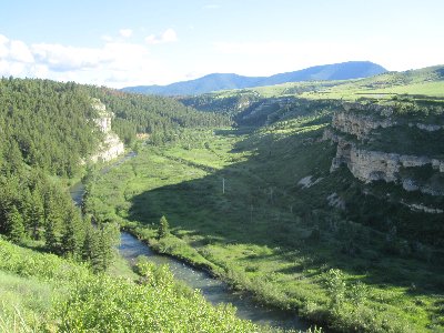
Drive through the rolling hills and mountains of Montana on your way from Glacier National Park’s east entrance in St. Mary to Yellowstone National Park’s north entrance. The drive can be done in either direction.

When leaving Glacier National Park and heading south on US-89, you will see rolling hills of grass far into the distance, welcoming you to the Great Plains. In 20 miles, consider a side trip from Kiowa to East Glacier Park via the Looking Glass Hill Road whose views are simply stunning. In 20 miles from Kiowa on US-89, you arrive in Browning, where you can learn more about the Native American history in this area at the Museum of the Plains Indian (M1).
Heading south, you arrive in Bynum in 58 miles. Consider a side-trip on Blackleaf Road which will bring you to Blackleaf Wildlife Management Area (H1) where you can see some of Montana’s wildlife, elk, mule deer, bears, mountain goats as well as beaver and muskrats in the lakes and streams. Continue to the end of the road for a spectacular view of the Blackleaf Canyon (H2).
Continuing south on US-89, you will cross the Teton River and ahead you will see Pine Butte. A side-trip down Teton Canyon Road follows the Teton River, and turning left on Pebbles Road will bring you to the Pine Butte Swamp Preserve Area (H3) where you can enjoy grasslands, hills, wildlife, and the 500-foot sandstone butte. Wildlife in the preserve features grizzlies and over 100 species of birds.
A few miles from the river is the town of Choteau. The Old Trail Museum (M2), is a must for dinosaur lovers, which not only includes Native American artifacts and the history of Montana, but is also the home of a full Maisaura skeleton. The first dinosaur egg in the Western Hemisphere was found at the nearby Egg Mountain.
Heading south for nine miles will bring you to Freezeout Lake, where migratory birds flock to during the spring and fall.
Continuing south on US-89 for another 45 miles, you arrive in the town of Great Falls. When Lewis and Clark visited here in 1805, Lewis exclaimed that this town had the grandest falls that he had ever seen. Due to damming, the falls are no longer grand, but the town’s Lewis and Clark National Historic Trail Interpretive Center (M3) is an excellent location to learn more about the famous Lewis and Clark Expedition.
Just up the road from the Interpretive Center is Giant Springs State Park (H4), where you can enjoy the Missouri River between the Black Eagle and Rainbow Dams. This area is one of the largest freshwater fronts in the United States.
Great Falls is also the home of the C. M. Russell Museum (M4) which displays paintings, sketches, and sculptures by Charles Russell depicting the Wild West.
Heading south on US-89, the 70-mile stretch of road between Belt to White Sulphur Springs is known as the Kings Hill National Scenic Byway. In 13 miles from Belt, stop at the Sluice Boxes State Park (H5) to enjoy a picnic near the canyon and the surrounding mountains or fish in one of its many lakes.
Nine miles from the Sluice Boxes State Park, you will enter the Lewis and Clark National Forest, home of eight mountain ranges. In 23 miles, you will arrive at the Kings Hill Pass and the popular Showdown Ski Area. During the summer months, you can drive up to the top of the Porphyry Lookout (V1) for an incredible panorama of the surrounding peaks. On a clear day, you can see the Absaroka Mountains near Yellowstone National Park.
Following US-89 for another 31 miles, you arrive in White Sulphur Springs where the Castle Museum (M5) allows you a chance to enjoy the Victorian-style architecture and historical museum.
In 78 miles, you arrive in Livingston and the drive continues on I-90 to exit 3333. The Livingston Depot Center (A1) is a railroad museum located at the design firm which created the 1900s Northern Pacific engine.
For a side-trip, head west on I-90 to Bozeman, and stop at the Museum of the Rockies (M6). American History, a planetarium and a world famous collection of dinosaur fossils make this a fascinating experience.
Livingston is also known as an excellent location for fishing. Mallard’s Rest Fishing Access (W2) offers a sandy beach on the Yellowstone River. To the west, you will see the Absaroka-Beartooth Wilderness where you can hike through its mountains, to its lakes and waterfalls, and to the east, you will see the Gallatin Mountains.
In 20 miles, approaching the town of Emigrant, Emigrant Peak rises 10,921 feet. Part of the Absaroka Mountains, this range comprises the highest mountains in Montana. To the west of the town is Gallatin Petrified Forest, featuring tropical trees preserved by minerals, suggesting that the area was a lot different during the age of the dinosaurs. To visit, you will need a permit that you can be purchased in Livingston or Gardiner.
Continuing south, the canyon becomes a gorge as the Yankee Jim Canyon’s walls get closer and closer together. The Yellowstone River continues through, and expert white-water rafters enjoy the rapids created here. Further up the road, stop to see the Devils Slide (V2).
In 6 miles, you arrive in Gardiner where the scenic drive ends. From here, continue on US-89 into the Yellowstone National Park.
Other Nearby Places of Interests
Gallatin Petrified Forest (H6): The Gallatin Petrified Forest are tropical trees that have been solidified from many years ago, suggesting that this climate was very different then. For a peak around, stop in Livingston or Gardiner for a permit.
Freezeout Lake (W1): During the spring and fall, more than 300,000 birds stop at this lake from all over the world.


